The Acadian aboiteau system uses wooden spars or stones layered with sod and placed under the surface of the tidal waters to allow fresh water from the marshes to release into the ocean while prohibiting salt water from entering. In a similar fashion, the Mi’kmaq fishing weir is designed to be used in tidal areas, with stone or wood fence structures placed below the surface of the water in a ‘V’ shape to allow some fish to come in but limiting their ability to get out. The Acadian aboiteau system was developed in the 17th century following Acadian settlement to what is now called Nova Scotia. There were two main towns which the Acadians built, named Port Royal and Grand-Pré. These areas reside next to tidal bodies of water on land traditionally owned by the Mi’kmaq people. Across their territories in Nova Scotia, New Brunswick, Prince Edward Island (PEI), and the Gaspé Peninsula, the Mi’kmaq had been using weir fishing systems for thousands of years before the Acadians first came to North America in the 16th century. Today, archaeological sites of Mi’kmaq fishing weirs have been found across all of these areas, and archaeological sites of Acadian aboiteaux systems have also been examined in Grand-Pré. Since the Acadians and Mi’kmaq people had long existing trade connections prior to the development of the aboiteau, it stands to reason that the Mi’kmaq use of tidal lands influenced the Acadian use of those same spaces, rather than the aboiteau being a creation of solely European decent.
This article will argue that the aboiteau system is influenced by the Mi’kmaq knowledge seen with the fishing weirs, as they both manipulate the landscape of Nova Scotia in similar ways. It should be noted that the Acadian’s European ancestry also, certainly influenced the development of the aboiteau, but the purpose of this research paper is to show that the aboiteau is a product of cross-culture production. This topic uses archaeological data from Jonathan Fowler’s (2006) site analysis at Grand-Pré, data from Helen Kristmanson’s (2019) excavation of a 2000-year-old Mi’kmaq fishing site, and research by Christopher Tilley (1994), Andrew M Bauer (2011), and Fraser Sturt (2006) on phenomenology, spatial production, and time/space geography. Combining the archaeological data of a Mi’kmaq weir site and a discovered Acadian aboiteau system in Grand-Pré, this essay aims to show how the lived experience of people in the same landscape inevitably generates the mixing of cultural practices. A final examination will then be conducted to show the validity of the claim that Mi’kmaq weirs and tidal productions influenced Acadian aboiteaux through their landscape connection.
Kerry Prosper, Image of One of the Mi’kmaq Stone Weirs Located on the Mersey River (ca. 2002: in “The Mi’kmaq Relationship With Kat” by Kerry Prosper and Mary Jane Paulette)
Overview
The Acadians settled in what is now Nova Scotia around 1604, and in less than 100 years they had developed their aboiteau systems as a way of cultivating the land which resided so close to tidal bodies of water. Despite settling down in the 17th century, the Acadians and Mi’kmaq had established trading connection during the 16th century when French fisherman would come to the shores of North America in the warmer months (Earle Lockerby 2004). Therefore, by the time the Acadians had begun building homes and cultivating land in Nova Scotia, they already had a relationship with the indigenous people in the area. Gregory Kennedy (2013) even writes that Mi’kmaq people married into Acadian families or lived on the borders of the Acadian settlements of Port Royal and Grand-Pré, which created later issues when the aboiteaux altered the wetlands that these people were used to living on. In the beginning the Acadians settled solely on Mi’kmaq territory, where the Mi’kmaq people had lived for thousands of years already (Lockerby 2004). In those thousands of years prior to European settlement, the Mi’kmaq had already begun using weir systems for fishing in tidal waters, including the areas close to Port Royal and Grand-Pré. Mi’kmaq traditional maneuver the land with the seasons, and thus they never stayed at the same area to fish or hunt (Lockerby 2004). This gave the Mi’kmaq a freedom of movement which allowed them to meet the Acadians and trade with them during the 16th century. Despite the shared landscape space that is seen through this connection, and the well-established relationship that developed between the Mi’kmaq and the Acadians prior to the aboiteau’s creation, archaeological investigations into the aboiteau (Whitney P Broussard III 2014; Matthew G. Hatvany 2002) have mostly focused on the European influence on its development with little regard for the impact that the Mi’kmaq people and their use of tidal marshlands had on the Acadians.
Since both communities of people were using tidal systems made up of wood or stones to create a one-way path of movement in the water, it seems wrong to suggest that the intelligence of the Acadian aboiteau is solely based in their European heritage. Instead, landscape archaeology can show how shared and lived spaces of people often influence production of that space on the various groups living there. In this case, by virtue of living on their land, trading and living with or next to Mi’kmaq people, and sharing the same materials would suggest that similarities in the ways they used the land is likely a result of cross-cultural phenomenology and not just a coincidence. Many scholars in the past and even today (Broussard 2014; Hatvany 2002), point solely to the European origins of the Acadians as the reason for the aboiteau’s development since the Mi’kmaq people never sought to transform their land in the quite the same way. By stating this belief, these scholars are perhaps perpetuation racist sentiments of the capabilities of the Mi’kmaq people and directly ignoring the intermingling that occurred between some Mi’kmaq people and some Acadians. It thus makes entirely more sense that the aboiteau is a product of cross-cultural connects and has both European and Mi’kmaq influences. Since there are many articles (Broussard 2014; Hatvany 2002) already written on the aboiteau’s European side, this essay looks at its potential Mi’kmaq connection and reveals how landscape archaeology can help us understand the many ways indigenous people have influenced colonial settlers, perhaps more than what is currently accredited to them.
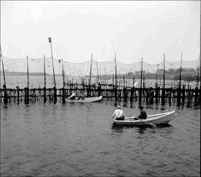
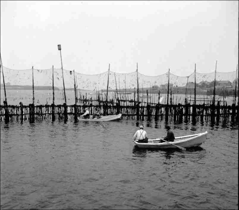
Westport Weir (ca. 1950: in “The ‘Last Weir’” by Rodney Stark)
Spatial Production, and Phenomenology and Time/Space Geography
Spatial production, as discussed by Andrew M Bauer (2011), sees meaning shift in the production of landscape and structures over the course of time. Bauer (2011; 88) uses the term landscape to refer to places that have changed their cultural meanings through history, as they were reproduced for different people and their subsequent activities which related to the material and symbolic environment in a space. Spatial production thus looks at what is defined in the reproduction of space by different people, and how this relates to their relationships with the landscape and people in a shared place. This idea also relates to ‘taskscapes’ (Bauer 2011; 88) and how mutual activities in a space speak to the shared landscape features and the relationships formed through shared places. The political aspect in spatial production comes from the concept of power in reproducing a space for a new group of people, as a way of defining it as their own (Bauer 2011). Structures that reflect the past then, suggests a level of respect given to the people who inspired the present group within a space, and this could be the reason why credit is often given to the Acadian’s European ancestry rather than the Mi’kmaq. If the Acadians were in fact inspired by the Mi’kmaq fishing practices, modern scholars would have to accept a level a subordinacy that the Acadians felt towards the Mi’kmaq when they first arrived. As the Acadians were a small group who historically struggled through the cold winters of what is now Canada, there is already evidence to suggest that they were willing to listen to the indigenous people for help surviving this land (Kennedy 2013). Therefore, spatial production can show how the Acadians reproduced spaces originally used by the Mi’kmaq people, and thus were influenced by the relationships formed in these shared places.
Fraser Sturt (2006) discusses the complications of landscape archaeology in analysing coastal or wetlands, as the body of water seems to be ignored in human production of space. However, in looking at tidal lands in regard to the water and its effect on people Sturt (2006) argues that much more can be learned about people in pre-history, or in this case with a lack of written narratives. Sturt (2006; 126) uses writings on time/space geography from Hägerstrand (1970) and Pred (1981) but combines it with water landscape and tidal lands. This concept shows how landscape has shaped human activity, rather than human activity shaping the land. This merges well with Christopher Tilley’s (1994) work on phenomenology, as the two address ideas of landscape effecting and influencing the way people interacted with and in a space. In Tilley’s (1994) work on phenomenology, landscape is seen as a product of the time, space, place, and people living in an area rather than outside of these things. This works well in explaining the connection between the Mi’kmaq fishing weirs and Acadian aboiteaux, as these groups shared tidal spaces and were influenced by the land and water within a shared landscape similar. They thus interacted with one another rather than people outside of their shared landscape. By looking at the time/space theory in relation to fishing weirs and aboiteaux, we can see the ways in which sharing space, natural water ways, and materials enabled a sharing of knowledge.
Pitawelkek and Grand-Pré
Pitawelkek is an archaeological site located on Georges Island in PEI and was identified in October 2006 by a small group of local archaeologists and Mi’kmaq leaders. The site, dubbed a “shell midden”, contains a plethora of shell, pottery, and other fragments across the whole area, making it harder to interpret the data of the site. What is of interest here though, is the wooden, tidal structure that was discovered buried beneath mud and stone (Helen Kristmanson 2019). Some of these stones are shaped with flat edges, and the soil shows a mold where wooden posts once stood in the ground (Kristmanson 2019; 7). Fragments of stone tools and animal bones were also found at Pitawelkek (Kristmanson 2019; 9), tools which Kristmanson says would have been used for cooking, dugout canoes, and making fishing weirs. These artifacts and structures at Pitawelkek have been dated (Kristmanson 2019; 4) to the Woodland period, specifically between 700 and 800 CE. As Mi’kmaq people traditionally moved with the seasons, this site was not a permanent settlement was likely used as a temporary space for fishing during the warmer months (Roger J Lewis 2006). Although some fishing weirs have been discovered, after hundreds of years most of them have been destroyed from the tidal waters they reside in (Kristmanson 2019). This makes Pitawelkek an intriguing site, as it shows the use of stones and wood spars for production in tidal landscapes. Despite the fact that this site dates to a pre-contact period, evidence also shows that people returned to this area after 1550 and reproduced the space for themselves.
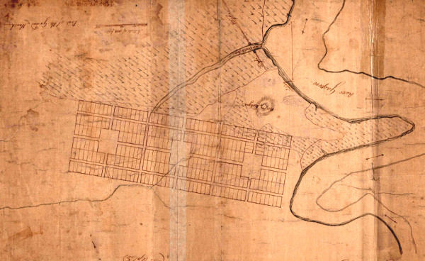
Charles Morris, Survey Map of Eastern Grand-Pré (ca. June 1760: University of New Brunswick, Fredericton)
Kristmanson discusses that other artifacts from Acadian settlements were also found close by the excavation site at Pitawelkek (Kristmanson 2019; 9). These artifacts, namely an axe, are believed to be of Mi’kmaq possession but of Acadian manufacturing. This suggests that around 850 years after the Mi’kmaq built a fishing weir on the site, they came back to fish there again and had either brough tools they traded with Acadian people or received trade goods after settling in Pitawelkek for a short period (Kristmanson 2019). The evidence of Mi’kmaq fishing practices in this space, both prior to contact and afterwards, and the evidence of contact with Acadian people, shows how likely it would have been for the Mi’kmaq to share knowledge with the Acadians. Fishing weirs were used so much by the Mi’kmaq in their annual fishing practices as well, that they were located all across their territory (Lewis 2006). Weirs are not conditional to Mi’kmaq or even North American indigenous people, as they are Neolithic designs (Lewis 2006; 2); however, the Mi’kmaq’s profound use of weirs in the 17th century compared to its European use, suggests that the Acadians would have come across it through the Mi’kmaq rather than their own knowledge of Neolithic fishing practices. Pitawelkek is a site that proves the prevalent relationship between the Mi’kmaq and the Acadians during the 17th century, where Acadians would have certainly come in contact with fishing weirs built by the Mi’kmaq people prior to developing the aboiteau.
Jonathan Fowler’s (2006) excavation of an Acadian aboiteau in 2006, revealed a new aboiteau location previously unknown to archaeologists at the time. The site is located in the Gand-Pré area, not on the edge of any modern-day water ways. But the wooden structure connected to a larger network of aboiteaux and was situated only two meters from the water (Fowler 2006; 3). This aboiteau is one of the oldest surviving ones in Nova Scotia, dating to the 1690s (Fowler 2006). The system used a large wooden spar cut in half and hollowed out, with stones surrounding it to keep the structure in place (Fowler 2006; 14). This section of the aboiteau connected to a sluice system on the coastline where water would have released back into the ocean. A flap was located inside the hollow wooden spar to allow movement in one direction but not the other, this directed anything inside the tunnel to move south (Fowler 2006; 11). Fowler points out that the date of this particular aboiteau is from the same time period that Sieur de Dièreville came to Port Royal and Gand-Pré and wrote letters back to France with details on aboiteaux (Fowler 2006; 19). Dièreville wrote (Broussard 2014; 161) that the Acadians worked with the seasons and the flow of the tides rather than against it. Aboiteaux were made by driving wood spars into the ground where the tidal waters meet the marshland. Between the large logs, smaller ones are placed on top of each other with clay fitted between each layer. This is the same system which Fowler excavated in 2006 and compares well with the Pitawelkek weir that used buried logs and stones to trap fish with the use of the tide.
Analysing the Structures
It is clear that the Mi’kmaq fishing weirs and Acadian aboiteaux used similar materials and were built in similar places. But this should be of no surprise since these structures were built on shared spaces, where only cultural meaning changed the way each group used the landscape. As spatial production shows us, the sharing of materials and landscapes helped define the ways in which each group produced or reproduced the land and tides. The Mi’kmaq lived in and around the areas where the Acadians settled, giving ample opportunity for both groups to come in contact with each other and therefore for them to share knowledge. This is seen in various accounts, including at the excavation of Pitawelkek. As Bauer (2011) discusses, space is defined by relationships, shared experiences, mutual materials, and changed meaning. In the case of the Acadians and the Mi’kmaq, the space where the weirs and aboiteaux were construction stayed the same. Material thus stayed the same too, and the shared experiences of this landscape provided both the Acadians and the Mi’kmaq ways to move and trap nature for their own ends. As Dièreville wrote (Broussard 2014; 161) the Acadians chose to work with the tidal waters rather than against it, in a similar fashion the Mi’kmaq also utilized the tides to their advantage instead of manipulating the landscape to change how the tides moved.
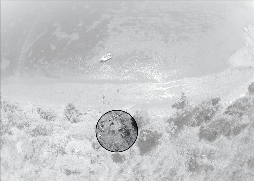
Pitawelkek site aerial view (ca. 2019: in “Pitawelkek: A 2000 year old archaeological site in Malpeque Bayby” Helen Kristmanson)
These similarities in production do not eliminate the changed meanings and symbolism that each group placed onto their structures, but rather it suggests a togetherness and a shared production history where one group is building off of the other (Bauer 2011). This idea thus suggests that the Acadians learned to work with the land from the ways in which the Mi’kmaq had produced the areas of Port Royal and Grand-Pré prior to colonial contact. Perhaps the Mi’kmaq had used these areas for fishing and left behind weirs from decades or centuries earlier, or the Acadians could have bridge together the knowledge from Europe with new knowledge gained from relationships with Mi’kmaq people who joined the community. It is hard to say for certain, but what spatial production does reveal is perhaps why so many modern scholars choose to disbelieve that the Mi’kmaq had any effect on the aboiteau. Spatial production shows the political aspects of space and places, by ways of what knowledge is used to produce and reproduce landscape. If the aboiteau is even partially inspired by the Mi’kmaq, then it gives credit to the intelligence of indigenous people in a way modern scholars seem to want to separate, as if indigenous people have never influenced Europeans in an intellectual and meaningful way.
Phenomenology and time/space geography suggests that people produce within a space using what they see and what they have within that space, as it is nature that affects people (Sturt 2006; Tilley 1994). This merges well with what has been discussed already, as it has become apparent that the Acadians had access to Mi’kmaq knowledge and the same materials used by the Mi’kmaq in the same spaces they produced fishing weirs. Although the Acadians originally came from Europe and had knowledge of some European practices, this does not mean they knew of every water system used by Europeans. Matthew G Hatvany (2002) suggests that dyke systems in parts of France, England, the Netherlands, and Denmark could have inspired the Acadian aboiteau, but this would require previous knowledge of those systems in order for them to be the source of inspiration. Phenomenology shows us that the more likely inspiration was based in what the Acadians had access to in the present time. Therefore, with an inability to get quick responses from European sources on dyke systems, the Acadians would have continued to develop the aboiteau regardless and likely looked at other more local sources for knowledge and inspiration. This local knowledge could have only come from the Mi’kmaq, as discussed before they had the greatest access to the Acadian settlements from the beginning and had already formed relationships with these people during the 16th century.
Further evidence that the Mi’kmaq influenced the Acadians can be seen in their own production of the land and tidal waters, where the weir becomes an example of how Mi’kmaq people interacted in time/space geography. The weir shows the influence that Nova Scotia’s tidal waters had on the Mi’kmaq, as they used it to push something in one direction while preventing it from moving back in the other direction. It is well known that the Mi’kmaq and Acadians shared land and resources, so it would be crazy to suggest that they did not share knowledge. As time/space geography suggests (Sturt 2006), landscape affects people and if there are two different groups of people within a shared space they are likely to be influenced by the land in similar ways, regardless of shared knowledge by way of mouth. In simpler terms, the Acadians and Mi’kmaq could have shared similar knowledge because they produced structures in a shared landscape. However, Gregory Kennedy (2013) discusses excavations at Port Royal which show the complex nature of Acadian aboiteaux.
The aboiteau included plant layers in between the wood pillars, so that as the plants grew, the aboiteau would become more stable (Kennedy 2013). Kennedy speaks to the fact that the Acadians would have learned this from their Mi’kmaq neighbours who lived close by and sometimes even married into the community. It seems so unlikely to modern scholars (Broussard 2014; Hatvany 2002) that a group from Europe would incorporate indigenous ideology and techniques into their way of life as they first settled in Nova Scotia. However, there is no requirement to be indigenous for a group to appreciate indigenous knowledge. This is clearly seen with the Acadians and Mi’kmaq, who both used the same land and materials to construct tidal systems that worked with nature to move something in one direction but not the other. These basic descriptions seem a far-fetched connection, but the Acadians had different objectives and cultural meanings placed upon the land in which they lived. Spatial production shows how this is a common concept, that one group’s changed meaning merge with preexisting knowledge to reproduce the land in ways that have both worked in the past and function in the present social landscape.
Conclusion
After observing the ways in which the Mi’kmaq people utilized land, space, and tidal waters for fishing, there can be comparisons made with the Acadian aboiteau. Whether the fishing weir is the direct inspiration for the Acadian sluice system is up to interpretation, but it cannot be ignored that there is a Mi’kmaq connection in the inherit design of the aboiteau. The ways that the Acadians worked with the water, the tides, the changing seasons, and the earth to create an irrigation system shows a deeper connection to the trade relationships formed between the Mi’kmaq and the Acadians. Despite what Hatvany (2002) and Broussard (2014) believe about the aboiteau being both unoriginal in colonial settlement practices and not of indigenous origins, they completely ignore the relationships formed in shared spaces and landscape production. Humans experience life observing themselves at the center and what they see around them as the main influence on their actions (Sturt 2006). This idea is plainly seen here, where the shared space between the Acadians and the Mi’kmaq had a greater effect on the aboiteau than European knowledge could have at the time. Without access to European engineers or libraries, the Acadians in the 17th century looked to their Mi’kmaq neighbours for help in their own development of the landscape. By ignoring the definite influence the Mi’kmaq had on the Acadians, even if they only partially influenced the aboiteau, is to ignore the credit due to indigenous groups in shaping North American culture. Many indigenous practices and beliefs can be seen woven into Western culture today, but it is often Europe that gets credited for producing these meanings and designs in our modern culture because of the inherit belief that indigenous culture is inferior. But the Acadian aboiteau system and its Mi’kmaq influences prove that indigenous knowledge was key to the success of the colonial survival in the early settlement years.
More on the Topic…
Warren A. Perrin, Phil Comeau, Mary Broussard Perrin. Acadie Then and Now. Andrepont Publishing, 2014.
P.G. Johansen and A.M. Bauer. The Archaeology of Politics: The Materiality of Political Practice and Action in the Past. Cambridge Scholars Publishing, 2011.
Journal of Maritime Archaeology 1, 2006.
Earle Lockerby. The Canadian Journal of Native Studies 24, 2004.
Flavie Deveaux
Bibliography: Bauer, A.M. “Producing the Political Landscape: Monuments, Water, Labor and Place in Iron Age Central Karnataka.” The Archaeology of Politics: The Materiality of Political Practice and Action in the Past, Edited by P.G. Johansen and A.M. Bauer, Cambridge Scholars Publishing, Newcastle (2011): 83-113; Broussard, Whitney P III. “The Acadian Aboiteau: A Cultural and Economic Keystone.” Acadie Then and Now 1, Edited by Warren A. Perrin, Phil Comeau, Mary Broussard Perrin, Andrepont Publishing (2014): 159-166; Hatvany, Matthew G. “The Origins of the Acadian Aboiteau: An Environmental-Historical Geography of the Northeast.” Historical Geography 30, University of Laval Press, Quebec City (2002): 121-137; Fowler, Jonathan. “Archaeological Salvage Excavation of a 17th Century Acadian Sluice from Grand-Pré Marsh.” Heritage Research Permit A2006NS53. Northeast Archaeological Research, Lower Sackville, Nova Scotia, 2006; Kennedy, Gregory. “Marshland Colonization in Acadia and Poitou During the 17th Century.” Acadiensis 42, No. 1, The Department of History Publishers, University of New Brunswick (2013): 37-66; Kristmanson, Helen. “Pitawelkek: A 2000 Year Old Archaeological Site in Malpeque Bay.” The Island Magazine. Canadian Museum of History and Parks Canada (2019): 2-14; Lewis, Roger J. Pre-Contact Fish Weirs: A Case Study From Southwestern Nova Scotia. Memorial University Press, St. John’s, Newfoundland (2006): 2-14; Lockerby, Earle. “Ancient Mi’kmaq Customs: A Shaman’s Revelations.” The Canadian Journal of Native Studies 24, No. 2 (2004): 403-423; Tilley, C. A Phenomenology of Landscape. Berg, Oxford (1994): 7-34; Sturt, F. “Local knowledge is required: a rhythmanalytical approach to the late Mesolithic and early Neolithic of the East Anglian Fenland, UK.” Journal of Maritime Archaeology 1 (2006): 119-139.
